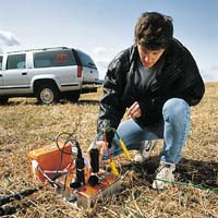
Geophysicists are scientists who study the structure and composition of the Earth. They use sophisticated instruments to measure physical properties such as:
- Density, electrical resistivity, electrical fields and radioactivity of rocks
- Velocity of sound waves transmitted through the ground
- Changes in gravity and magnetic fields of the Earth
- Reflection of radio signals from rocks near the Earths surface
Geophysicists use one or more of these measurements to find oil, natural gas, potash, coal, iron, copper and many other minerals. In addition, the properties are used to identify environmental hazards and evaluate areas for dams or building construction sites.
In research, Geophysics contributes to an understanding of the internal structure and evolution of the Earth, earthquakes, the ocean and many other physical phenomena.
While there are many divisions of geophysics such as oceanography, atmospheric
physics, climatology, and planetary geophysics, this brochure describes three
of the most popular branches of geophysics:
- Petroleum Geophysics
- Environmental Geophysics
- Mining Geophysics
The final part of the brochure provides information on employers, salary and training for each of these branches.
Geophysics & Computer Technology
"During the last several decades, geophysicists have created and commercialized profound technical innovations ... These advances have fundamentally changed natural resources exploration and production."
James D. Robertson, President of SEG The Leading Edge May 1995.
The technical innovation that Mr. Robertson refers to have been possible because
geophysicists have pushed forward the frontiers of computer applications. Geophysicists
use specialized computer skills and many are actively involved in the development
of hardware and software. Their efforts have resulted in leading edge equipment
and sophisticated work-station based computer applications capable of complex
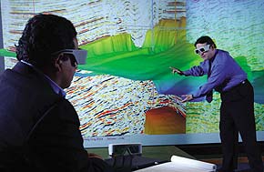
graphics. Computer technology has become an integral component in geophysics,
especially for processing the huge, modern offshore 3-dimensional seismic surveys.


