Interpretation Geophysicists
Interpretation geophysicists are involved in every aspect of the seismic work
from planning the survey, overseeing the data collection and interacting with
the processors through to the final interpretation. They often go to the ‘field’ to
observe the data acquisition.
Interpretation geophysicists interpret the seismic
data using all available geological information to determine the most reasonable
picture of the Earth.
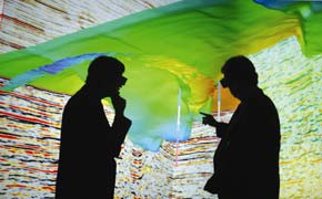
Interpretation is done on fast, interactive workstations and often projected
onto large screens in ‘visionariums’.
Interpretation geophysicists
frequently work as part of a team which includes geologists, engineers,
land negotiators and computer specialists. They combine
their talents to develop 'plays' and decide where to drill wells to find
new oil and gas reserves. Such teams exist in most oil companies.
Competition between oil companies is strong and they are constantly trying
out new ideas, techniques and equipment to give them an edge in the search
for exploitable resources. The secret nature of the data is strongly protected
and all interactions are carried out in a professional, confidential manner.
THE 'PLAY'
When the oil industry uses the term 'play' it refers to a prospect or idea which might result in discovering oil or gas.
The word 'play' captures the sense of excitement and adventure that geophysicists feel when they are pursuing a concept using all their creativity and ingenuity. It's the sense of having a huge puzzle to solve and winning with the right answer.
Three-Dimensional Seismic Survey
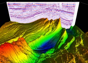
One of the most exciting and complex techniques developed in recent years has been the three-dimensional (3D) seismic survey. This method has required much research and experimentation in all phases of petroleum geophysics. As a result, geophysicists now have access to more sophisticated field equipment, larger capacity computers and more complex software.
The use of 3D seismic method has resulted in a tremendous improvement in the success oil companies have in finding oil and gas. It has been so successful that it is now being tried in the mining industry (see Mining Geophysics). Today, of all existing geophysical tools, 3D seismic gives the clearest image of those hidden earth layers.


