Abstract
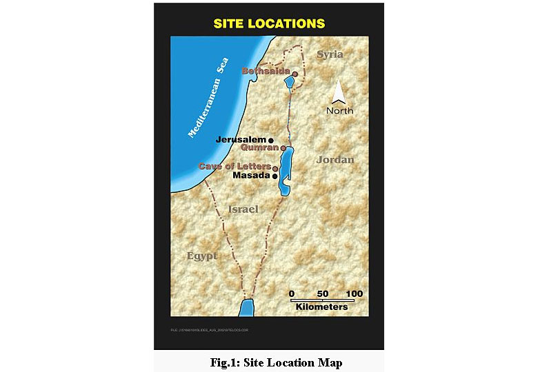
For seven weeks over the past three summers, archaeogeophysical exploration was carried out in caves and other ancient sites of occupation along the Syrian African Rift Valley from the Dead Sea northward to the confluence of the Sea of Galilee and the Jordan River. State of the art geophysical exploration tools were used to non-destructively provide an overview of the hidden architecture of ancient cities, identify the buried locations of specific artefacts of interest, locate caves that may have been sealed off by earthquake activity sometime in the last 2000 years, and sterilise sites that were unlikely to yield structures or artefacts. Instruments used in these investigations included a two-dimensional (2-D) electrical resistivity imaging system, a fixed frequency terrain conductivity mapping instrument, a very fast high resolution transient EM metal detector, an Overhauser gradiometer and base station, a hobbyist type metal detector, several ground penetrating radar (GPR) systems, and a kite-borne aerial photography system. See Figure 1.
Bethsaida
Of the seven sites where geophysical surveys were performed, detailed investigations were carried out at three sites. The northernmost of these three sites is Bethsaida, which is situated near the confluence of the Jordan River and the Sea of Galilee. Bethsaida is an important New Testament site as it is mentioned more often than any other city except for Jerusalem and Capernaum. According to the Gospel of John, Bethsaida was the home of the disciples Philip, Andrew and Peter. The New Testament tells us that Bethsaida is where Jesus fed the five thousand, cured the blind man, and walked on the water. Yet, as compared to other sites of religious significance, very few people have visited or even heard of Bethsaida. The city was likely destroyed by a tsunami from the Sea of Galilee in the second century C.E. (common era). Uplift in the Golan Heights, dropping sea level, and a prograding Jordan River delta all conspired to move the shoreline 2.5 km from the site of this famous fishing town. For seventeen centuries, crusaders, pilgrims, and archaeologists never thought to search for Bethsaida at such a distance from the coast. Only in 1987 did archaeologists and geologists from the University of Nebraska at Omaha correctly identify this 22-acre mound.
As the city was built of basalt and is perched on a Tertiary basalt flow, magnetics, GPR, and 2-D resistivity are being used to map the architecture and paleo-relief of the site. GPR has been particularly useful in locating small-scale architectural features that require fine scale vertical resolution. Features identified by GPR include the tenth century B.C.E. (before the common era) gate underlying the already excavated ninth century B.C.E. gate complex; a road underlying the excavated Roman period road, several tunnels, and a tower. Magnetics has been useful in mapping basalt walls and courtyards. 2-D resistivity has been particularly useful in imaging some of the larger features such as the main wall of the upper or inner city and areas of dense housing outside the inner city. After 15 years of excavation, less than five percent of the city has been unearthed. The main objectives of using geophysical techniques at Bethsaida are to provide the archaeologists with a broad image of the city and to focus digging efforts on specific areas of interest.
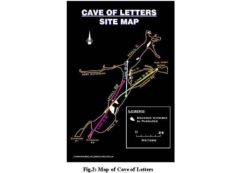
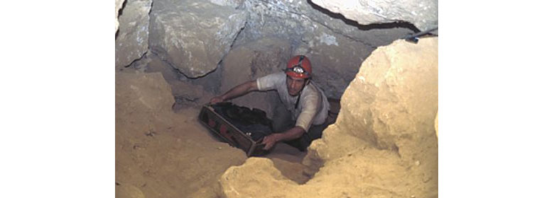
In 132 C.E., the Jewish population of Palestine rose up against the Roman Empire in what became known as the Second Jewish Revolt. By 135 C.E., 585,000 Jewish combatants had been killed, tens of thousands of others had died of famine and disease, and 985 cities and towns had been destroyed. The last surviving rebel commanders and their families fled to remote caves along the western shore of the Dead Sea. The Cave of Letters is one of the more well known of these refuges as it was here, in the winters of 1960 and1961, that Israel's most famous archaeologist, Dr. Yigael Yadin, made a spectacular series of finds that has become part of the patrimony of the country. Besides some of the largest, most varied, and best preserved collections of Roman glassware, bronzeware, keys, and clothing, the cave yielded the largest single cache of papyrus scrolls found anywhere in Israel. Many of these eighteen-century-old scrolls were military commands dated and signed by "Simon Bar Kochba, President of the State of Israel." Hence, the site became known as the Cave of Letters. See Figure 2.
Despite Yadin's tremendously successful expeditions, Dr. Richard Freund believes that there are many more artefacts to be recovered. Yadin understood that the floor of the cave, as he found it in 1960, was identical to the floor in 135 C.E. Freund feels that the floor on which the rebels lived is buried under a significant thickness of roof fall debris caused by the powerful earthquakes which frequently strike the Rift Valley. The main objectives of the geophysical exploration in the cave were to specifically target buried artefacts, and to identify and delineate this hypothetical existence of a "Bar Kochba floor." Metal detectors, an EM instrument, and an Overhauser gradiometer were used in the search for artefacts. GPR and 2-D resistivity were used to image the level of rebel occupation.
Qumran
The Dead Sea Scrolls are approximately 900 different manuscripts discovered in eleven caves in the immediate vicinity of the ruins of the 2000-year-old community of Qumran. Despite intensive searches in the hundreds of other caves in the vicinity of Qumran over the last 45 years, the scrolls were all discovered between 1947 and 1956. Included among the scrolls are every book of the Hebrew Old Testament except the Book of Esther. The scrolls predate any other version of the Bible by more than 1,000 years. Thus, the Dead Sea Scrolls are often referred to as the most important archaeological find of the last century, if not the last millennium. Qumran is perhaps the most important archaeological site in the world from the perspective of the development of Judeo-Christian civilization.
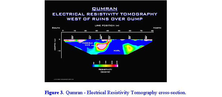
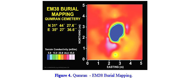
Many archaeologists believe that other scrolls exist in caves that were open 2,000 years ago, but were sealed off some time before 1947 by earthquake activity. GPR, 2-D resistivity, and EM were used to search for subsurface voids. With the intention of better understanding the burial practices of the people of Qumran, GPR, EM, and metal detection surveys were carried out over the 1,213 interments in the cemetery. Two very unique burials were identified, one of which is likely that of the "Teacher of Righteousness" mentioned extensively throughout the Dead Sea Scrolls. Low-level kite- borne photography was used to document this burial. See Figure 3 & Figure 4.

Biography
Paul Bauman is a Professional Engineer with over 20 years of geophysical exploration experience in the environmental, water resource, mining, oil and gas, and archaeology sectors. Paul has a B.Sc.E. in geological engineering from Princeton University, a minor in Near Eastern Studies also from Princeton, and an M.Sc. from the University of Waterloo in hydrogeology. He worked for Schlumberger International from 1981 to 1986 in Borneo and Papua New Guinea. In 1990, Paul created and has since managed the near surface geophysics group at Komex International Ltd. This group numbers about 20 geophysicists and has worked on every continent in the world.