Abstract
In exploration seismology, most common type of the near-surface is defined as the depth interval below the topography, composed of a low-velocity, unconsolidated, heterogeneous soil column and weathered rock layer. As such, raypaths are close to vertical incidence within the near-surface --- a requirement for statics corrections to be acceptable. This definition of the near-surface does not apply to the case of a rock outcrop. Hence, if it is near the surface, it is not always the near-surface within the context of the definition above. In contrast with the near-surface defined above, the subsurface is composed of relatively higher velocity, consolidated rock layers. As such, the interface between the near-surface and the subsurface often gives rise to a strong shallow reflection.
I shall describe an image-based method, which makes use of the strong reflection at the base of the near-surface, to estimate a model for the near-surface for statics corrections. This image-based method would not be applicable if a strong reflector associated with the base of the near-surface is unidentifable. The method (termed i-stats for brevity) is based on prestack depth migration of shot records from a floating datum that closely resembles surface topography using a range of near-surface velocities. The resulting depth images form an image volume which can then be interpreted to pick the reflector associated with the base of the near-surface and to pick the velocities for the near surface from the corresponding horizon-consistent semblance spectrum. The estimated ‘equivalent-medium’ model for the near-surface comprises laterally varying velocities, only, but yields essentially the same statics that one calculates from a more complicated model for the near-surface that may be estimated from inversion methods. The equivalent-medium model of the near-surface conforms to the vertical raypath assumption that underlies statics corrections. I shall demonstrate the i-stats method to correct for the deleterious effect of near-surface anomalies associated with sand dunes, shallow anhydrites, glacial tills, salt-filled karstic near-surface on subsurface reflections.
In areas with complex near-surface with irregular topography and complex subusrface, there is much uncertainty in rms velocity estimation for prestack time migration, whereas interval interval velocity estimation for prestack depth migration is despairingly challenging. We often attribute the velocity uncertainty to strong lateral velocity variations, heterogeneity, anisotropy, and three-dimesional behavior of complex structures. Nevertheless, it is not easy to identify the cause of and account for the ucertainty as it often is a combination of the various factors. And the analyst struggles with much difficulty when picking a velocity function whether it is for prestack time or depth migration.
We can never claim to resolve the velocity uncertainty completely. But, to some extent, this uncertainty can be reduced if we apply an appropriate multichannel signal processing to an image volume obtained by prestack time migration of shot gathers using a range constant velocities, in addition to the single- and multi-channel signal processing applied to shot and CMP gathers. The then much improved image volume can be used to pick rms velocities for prestack time migration with reasonable confidence. Yet, the multiplicity of semblance peaks associated with the image volume remains to be perilous. Rather than struggling to eliminate the velocity uncertainty completely --- an impossible task, I shall present a workflow to circumvent the velocity uncertainty. Starting with the image volume with the improved event coherency by multichannel signal processing, we can sum over the velocity axis to obtain a composite image in time so as to preserve all events in the image volume and avoid committing ourselves inadverdently to a velocity field which most likely would have some uncertainty. This summation strategy, however, works if the events within the volume are stationary in time and space. To meet this requirement, we first unmigrate each of the image panels within the image volume and then sum over the velocity axis. The resulting unmigrated section actually is equivalent to a zero-offset wavefield. The final step in the workflow is to perform poststack time migration of the zero-offset wavefield. I shall demonstrate this workflow using a field data set from an onverthrust belt.
Biography
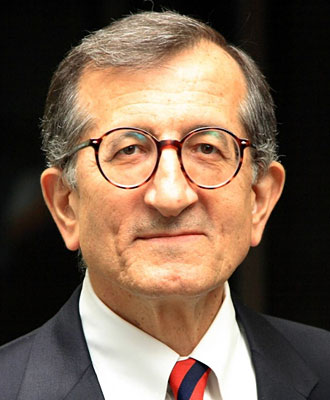
A Biosketch of Öz Yilmaz
- Öz Yilmaz received his B.S. in Geology with Geophysics Option from the University of Missouri-Rolla in 1970,
- M.S. in Geophysics with research in rock physics and earthquake seismology from Stanford University in 1972, and after five years in the industry,
- Ph.D. in Geophysics with research in exploration seismology from Stanford University in 1979.
- Aside from numerous publications on all aspects of seismic data analysis, Oz wrote a book entitled Seismic Data Processing published by SEG in 1987,
- The expanded, two-volume second edition entitled Seismic Data Analysis was published, again by SEG, in January, 2001.
- And his third book is entitled Engineering Seismology published by SEG, May, 2015.
- He was honored by the Society of Exploration Geophysicists (SEG) in 1991 with the Virgil Kauffman Gold Medal Award and by the European Association of Geoscientists and Engineers (EAGE) in 1992 with the Conrad Schlumberger Award.
- His biography has been included in Who’s Who in the World, 1998 edition,
- He was elected a member to the European Academy of Sciences in 2002,
- He was honored by his Alma Mater University of Missouri-Rolla with an Honorary Professional Degree in Geology and Geophysics in 2003, and
- He was elected by the SEG in 2011 as Honorary Member.
- Öz Yilmaz was the SEG Distinguished Lecturer in 1996 and Distingusihed Instructor in 2015.
- Öz Yilmaz is the Director of Anatolian Geophysical, which provides services in exploration seismology, engineering seismology, and earthquake seismology.
- Öz Yilmaz also is the CTO of GeoTomo LLC, which provides seismic software products and services in near-surface and subsurface modeling and imaging.


